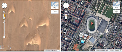
Dunes of the Kharga Oasis and the Olympic Stadium of Torino
Several methods exist for surveying the dunes and estimate their migration rate. Among methods suitable for the macroscopic scale, the use of the satellite images available on Google Earth is a convenient resource, in particular because of its time series. Some examples of the use of this feature of Google Earth are here proposed.
AC Sparavigna, DISAT, Politecnico di Torino
Saturday, August 17, 2013
Thursday, August 15, 2013
From Google Earth to Tatooine
On 11 August 2013 I found this article entitled "Star Wars home of Anakin Skywalker threatened by dune" http://www.bbc.co.uk/news/science-environment-23375344 It is told that "Sand dunes migrating over the Tunisian desert are poised to bury a famous Star Wars film set. The buildings of the fictional city Mos Espa featured in The Phantom Menace, "Episode I" of the Jedi saga. Sited on the planet Tatooine, this was the home of the young Anakin Skywalker ... Scientists have used the dwellings as a fixed geographic reference to measure the migration of giant wind-blown crescent-shaped dunes, or barchans. They have published details in the journal Geomorphology." The paper is in press, and you can see it at
http://www.sciencedirect.com/science/article/pii/S0169555X13003486
BBC continues "Ralph Lorenz, from Johns Hopkins University, ... visited the Mos Espa site in 2009, and noted that part of a nearby set used in Star Wars Episode IV: A New Hope had already been overrun. Using satellite images of the site, they were able to determine the speed of dune movement, which is approaching the buildings once inhabited by such luminaries as Anakin, his slave owner Watto, and rival podracer Sebulba".
Before these "Dunes on the planet Tatooine", on 4 January 2013 it was published my "Moving Dunes on the Google Earth", as you can find at http://arxiv.org/abs/1301.1290, where I showed how to use the time series of the Google Earth to estimate the motion of the barchans. I used the barchans in Peru. I have also discussed how to use reference points and adjust the Google images to have a "movie".
It seems that the authors of "Dunes on planet Tatooine: Observation of barchan migration at the Star Wars film set in Tunisia" do not know my "Moving dunes on the Google Earth" because my paper is not cited.
Therefore I cite myself!
And show you a "movie" of the barchan which is threatening Luke Skywalker's home.
Sunday, August 11, 2013
Moving sand dunes on the Google Earth
"Moving dunes on the Google Earth" is my paper on arXiv, published 4 January 2013. It shows how using GH time series you can see the motion of dunes. Here an example.
To see a movie, please visit Moving sand dunes ... post
Subscribe to:
Comments (Atom)

